
Old Mill Lane

You are standing on Old Mill Lane which links to Wakefield Road and Huddersfield Road. This area has a long-established industrial history, particularly in milling, benefitting from direct access to canal and water supply. As you read on, you can find out more about the mills that once proudly stood here, along with the tollgate house, the goods yard, the industrial railway line, and the chapel that used to be part of this landscape.
Old Mill Lane’s history is reflected in various historical sites and landmarks. Some of these can still be found:
-
Former Old Mill Lane goods yard
-
Former Old Mill Wesleyan Reform Union chapel
-
The Fleets lake
Have a wander down Old Mill Lane and see if you can spot where these buildings once stood and other historical features.
This trail is one of the five trails created as part of the Love Where You Live programme. All research were conducted by Project Archivist James Stevenson with invaluable support and input from Councillors Phillip Lofts, Jo Newing, and Clive Pickering.
Star Paper Mill
The Old Mill later became the Star Paper Mill which played a significant part in Barnsley’s industrial history. The site is now occupied by the Asda superstore. Behind the superstore lies The Fleet Dam, a lake that is popular with anglers and walkers and once served as an important water source for the mills. Many locals still remember their relatives and friends who used to work at the Star Paper mill.
In 1930, the Star Paper Mills company was purchased by Kymmene Aktiebolag, a company from Finland. The following year, 1931, the company purchased the Dearne Paper Mills from Yorkshire Paper Mills Limited.
-
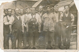
Staff at the Star Paper Mill -
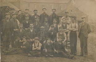
Staff at the Star Paper Mill

Old Mill
Research for the Old Mill has been referenced from the ‘Water Mills and Furnaces on the Yorkshire Dearne and its Tributaries’ by Tom Umpleby, published by Wakefield Historical Publications, 2000, pages 131-133. The evidence assembled in the volume suggests that the Old Mill was situated where Old Mill Lane crosses the River Dearne, on the west side of the road and the south side of the river.
It was a water-powered mill, with the water likely to have been diverted from the river into a mill race (channel) at the point where a weir is still visible on the river, then passing through the mill buildings before re-joining the river.
It was a mill for grinding corn and dated from at least the 15th century. This original building was taken down in 1802, when it was described as ‘Naylor’s old corn mill’. Four pairs of mill stones and dressing machinery were offered for sale in that year.
The same year, 1802, the mill was rebuilt and fitted out for dressing and spinning flax as part of the locally important linen industry. Once again, the mill was powered by water, but in 1828 new technology was introduced and the mill became powered by steam. The mill remained as a linen mill until at least 1850, when it was marked as such on the Ordnance Survey map surveyed in that year and published in 1852.


Later in the 19th century, the building was absorbed into the premises of the Dearne Paper Mill.
“The Barnsley Mill operations under the name of Dearne Paper Mills were started in 1860, situated on the banks of the River Dearne and close to the canal. Before being absorbed by Star its career had been chequered in the extreme, having changed hands four times with three of its owners having gone bankrupt.”
Source: The Centenary Booklet of Star Paper Limited, 1975.
Barnsley Archives Reference: A-116-F/3/1
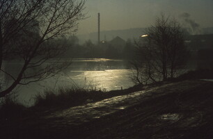
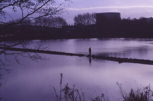
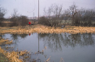
The Fleets Dam

Originally created by flooding the low-lying fields adjacent to the Dearne, this is where the water for the paper making process was stored. What remains of the four separate smaller ponds now form part of the wet woodland area - a valuable wildlife habitat. The remians of what was probably a boathouse still exists in the south east corner of the dam. It is now a popular fishing lake.
.JPG)
.JPG)
Tollgate House
Tollgate houses or tollhouses were built by turnpike trusts during the 18th and early 19th centuries for toll collectors to live in while collecting tolls from travellers for the maintenance of roads. They were often located beside toll gates on toll roads. The houses typically would have bay windows on front offering better visibility for the pikeman to see the road. With the decline of the turnpike system and railways development, many tollgate houses were sold off or demolished and only a few still exist today for other uses.
According to various editions of the Ordnance Survey map, the tollgate house at the bottom of Old Mill Lane appears to have stood until the 1940s. The tollgate house was managed by the Wakefield and Sheffield Turnpike, established in 1759, a division the of Leeds and Sheffield Turnpike Trust.
-
%20Day's%20Court%20block%20plan.jpg)
the ‘new’ Tollgate Inn of 1911 shows a stable block was built very close to ‘Old Toll Bar House’. Reference: Monk Bretton UDC BCP/144. -
%20elevations.jpg)
-
%20elevations.jpg)
The Tollgate House later operated as a public house after the turnpike system was phased out in the 1870s. Over the years, it became a well-known local landmark passing through several owners - from the Tollgate Hotel to Antonia’s Fun Bar, Bentley’s, and later the Time & Place pub.
.JPG)
-
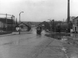
The Tollgate on Old Mill Lane during flooding in April 1970 (c) Barnsley Archives and Local Studies -
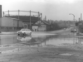
Tollgate House on Old Mill Lane has now been demolished and replaced by shop units on the site with route of the Turnpike Road to left of the ‘new’ main road.

Former Old Mill Lane goods yard
The original railway line located here was part of the South Yorkshire Railway, British Coal Railway. It started from the bridge at the junction of Old Mill Lane and Wakefield Road to the northern boundary of the Old Mill ward, just north of the Smithies Depot and immediately north of the site of the former Wharncliffe Carlton Colliery.
The Old Mill Lane goods yard was part of this former railway line, located on the west side of the LNER Nostell to Stairfoot line. It handled all sorts of goods ranging from coal to potatoes. The yard closed on 30 March 1959. The goods yard shed remains and the building is now commercial and industrial premises.
The route of this former railway now forms the walking / cycling path called ‘The Coal Line’.

'The Coal Line' takes you thorugh the Fleets all the way to Mapplewell, Royston and Carlton. The roite also leads to the Trans Pennine Trail which means you can walk all the way from the Fleets to Rabbit Ings with minimal roads to cross.

Barnsley Coal Railway
The Barnsley Coal Railway was incorporated in 1861 with the aim to provide a northward link between the South Yorkshire Railway and River Don Navigation at Ardsley and Wakefield. The first section was opened in 1863 but ended at Applehaigh, near Notton, largely due to opposition from the Wooley Estate. There were several failed attempts to finance an extension to Wakefield which became known as the ‘Barnsley Slump’. The Manchester, Sheffield and Lincolnshire Railway took over and completed the link in 1874. It opened for transportation of goods on 28 January 1870 and to passengers between Stairfoot and Lee Lane on 1 September 1882. The scheduled passenger service ended in 1930 and goods services in 1961
Barnsley Canal
The Barnsley Canal ran from Barnby Basin, passing through Barnsley, before joining the Aire and Calder Navigation near Wakefield. It was constructed in the 1790s with the aim of transferring coal from Barnsley coalfields to wider markets.
Barnsley Canal had a significant impact on Old Mill Lane, turning the area into a thriving industrial hub. Mills, warehouses, and workshops developed along the route, relying on the canal to move coal and other goods. However, the arrival of railways in the 1840s led to a decline in canal traffic, though it remained profitable until 1942. In 1953, the Barnsley Canal was officially abandoned and the Dearne aqueduct was demolished. Old Mill Lane gradually evolved into the modern road and commercial area seen today.
Learn more about the canal in this talk which Stephen Woodcock gave for the Barnsley Civic Trust in 2025
Old Mill Wesleyan Reform Union Chapel
The Old Mill Wesleyan Reform Union chapel stands at the northern end of Old Mill Lane on a parallel side road called Peel Place.
The chapel opened in November 1888. At this date, prior to the extension of the Borough boundaries, it was just within the parish of Monk Bretton.
A new block containing two classrooms was built on a site slightly to the south of the chapel and opened in January 1910. This block was ‘by the side of the Dearne Athletic Grounds’ and is marked as a Sunday School on the 1931 edition of the 25 inch-to-the-mile scale Ordnance Survey map.
24 members of the Old Mill Chapel Bible Class served in the World War I, but sadly, three of them did not return.

The chapel closed on 1 July 1956.
Although the former Sunday School has been demolished, the chapel building still stands. The whole Peel Place area is now occupied by small commercial and industrial premises. The chapel appears to be the only surviving building of the small residential community which once existed at Peel Place.
This Heritage Trail plaque is one of the five plaques created as part of the Love Where You Live programme. Barnsley Heritage Trail leads you through centuries of Barnsley’s history, with each historical site / landmark offering a glimpse into a different chapter of our past and the ways it has shaped our community you see today. All research were conducted by Project Archivist James Stevenson with invaluable support and input from Councillors Phillip Lofts, Jo Newing, and Clive Pickering.